Garmin Pilot
Garmin DCI
4.7
Advertisement
Detalhes da Versão
| País do Editor | BR |
| Data de Lançamento no País | 2014-07-17 |
| Categorias | Navigation, Weather |
| Países / Regiões | BR |
| Website do Desenvolvedor | Garmin DCI |
| URL de Suporte | Garmin DCI |
| Classificação do Conteúdo | +4 |
Advertisement
30 Days Free Trial on initial download!
Plan. File. Fly. Log.
Garmin Pilot is the most comprehensive suite of tools for the iPad designed specifically for general aviation and corporate pilots. Flight planning, charts, interactive maps, weather briefing resources and navigation capabilities; it’s all included. The app’s intuitive interface mirrors those on the newest Garmin touchscreen avionics so you can go seamlessly from preflight to inflight.
Plan
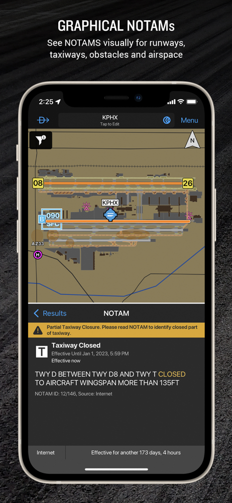
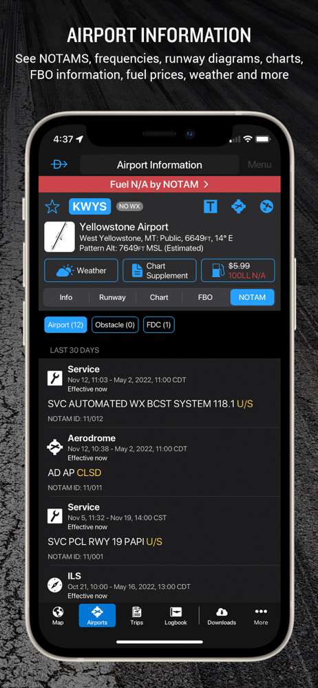
Garmin Pilot’s powerful capabilities start with pre-flight planning, providing pilots with the most comprehensive aviation weather information to make better-informed flight decisions. Pilots can check NEXRAD radar, visible and infrared cloud imagery, METARs, TAFs, AIRMETs, SIGMETs, PIREPs, NOTAMs, winds and temperature aloft, TFRs and lightning data. With Garmin Pilot, data can be displayed over Garmin’s interactive maps that support track-up navigation, VFR sectional or an IFR low or high en-route chart to visualize the weather for your route. Add text-based weather widgets and use the exclusive NavTrack feature to view weather along the planned route.
File
With Garmin Pilot, users can easily enter a flight plan and interactively edit it on the map. Pre-loaded forms make it quick to save and reuse data for frequently flown routes. And when the flight plan is ready, Garmin Pilot makes it simple to file, amend or close the flight plan via Leidos Flight Service or DUATS.
Fly
Garmin Pilot provides full en-route navigation capability on its moving map. Pilots can also navigate with Garmin’s patented panel, a GPS-driven instrument pack with a graphical HSI directional display and indicators for groundspeed, altitude and vertical speed. After takeoff, pilots can continue to view real-time weather in the U.S. and traffic information by wirelessly connecting to Garmin’s GDL 50 series portable ADS-B Receiver (sold separately).
Log
Garmin Pilot includes a comprehensive electronic logbook that syncs with flyGarmin. The logbook automatically generates entries based upon GPS data collected during the flight, tracks currency, supports manual entries, endorsements and creates reports.
Garmin Pilot U.S. Standard:
- Rich, interactive maps support Track-Up navigation
- Charts: VFR Sectionals, low and high IFR en-route, airport diagrams and approach procedures
- Ability to view Jeppesen Terminal Charts (Jeppesen echart subscription required)
- Weather Maps: Animated radar, Infrared and Visible Satellite, AIRMETs, SIGMETs, Lightning, TFRs and more!
- Extensive text products: METARs, TAFs, Winds Aloft, PIREPs, AIRMETs, SIGMETs, Area Forecasts and NOTAMs
- AOPA Airport Directory
- Weight and Balance
- Checklists
- Flight plan filing via Leidos Flight Services
- Garmin patented navigation panel
- Terrain and Obstacles
- Smart Airspace
- Fast Find predictive Waypoint Entry
- Logbook
- Optional VFR Premium: Synthetic Vision (SVX), Terrain and obstacle alerting, and Garmin SafeTaxi®
- Optional IFR Premium: VFR Premium plus geo-referenced Garmin FliteCharts®
Garmin Pilot has regional offerings for Africa, Asia, Australia, Canada, Europe and Latin America. Features include:
- Worldwide Jeppesen NavData
- Rich, interactive maps support Track-Up navigation
- Radar and Satellite imagery for Western Europe, U.S., Canada and Australia
- Ability to view Jeppesen Terminal Charts (Jeppesen echart subscription required)
- Worldwide METARs, TAFs, AIRMETs, SIGMETs, NOTAMs and winds aloft
- VFR Flight Plan Filing
- IFR autorouting and Flight plan filing in Europe
- Terrain and Obstacles with alerting
- Synthetic Vision (SVX)
- Smart Airspace
- Logbook
- Optional VFR charts from DFS, IGN and NATS and IFR enroute charts from EuroControl
- Optional Garmin FliteCharts® and SafeTaxi® diagrams available on a country-by-country basis
Note: Use of GPS running in the background may decrease battery life.
Note: One subscription to Garmin Pilot may be used on three devices.
Avaliação Média
306
Desagregação das Avaliações
Avaliações em Destaque
Por Felipe Ornellas
2023-05-03
Versão 11.2.1
Cada dia melhorando mais. Seria excelente uma ferramenta de ideal de descida (TOD).
Por Celsomon
2018-05-14
Versão 9.3.1
Até agora, na avaliação, vi que o que oferece é de excelente qualidade. As oportunidades de melhora seriam criação de link para download das cartas descida IFR do Brasil e gravação do track da rota voada. Essa última sugestão de melhora, facilita bastante debriefing. O gol mesmo desse programa, pelo menos para aviação militar, foi poder, com muita facilidade, planejar padrões de busca SAR. A questão das cartas IFR do Brasil acredito que seria de fácil implementação visto que são de graça e já existe o link para download das cartas de rota IFR. No mais, é um excelente aplicativo e dos mais completos que já vi. Parabéns a Garmin!
Por Raphael150
2024-11-24
Versão 24.11.0
BugsRecebi e-mail para atualizar a assinatura, e assim o fiz: paguei mais de 100 dólares no dia 1° de Novembro. O problema é que o meu app não atualizou após essa renovação, e no dia 16 de Novembro o app deslogou por falta de assinatura. Escrevi para a Garmin, e a assinatura nova foi efetivada, mas ao invés do vencimento ser no dia 16, ficou para o dia 1°. Escrevi para eles informando desse problema, mas o suporte da Garmin é péssimo! Até agora está constando dia 1° de Novembro como término da assinatura.
Capturas de Tela