OsmAnd+ — Maps & GPS Offline
OsmAnd
4.4
Advertisement
Advertisement
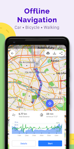
OsmAnd+ is an offline world map application based on OpenStreetMap (OSM), which allows you to navigate taking into account the preferred roads and vehicle dimensions. Plan routes based on inclines and record GPX tracks without an internet connection.
OsmAnd+ is an open source app. We do not collect user data and you decide what data the app will have access to.
Main features:
OsmAnd+ privileges (Maps+)
• Android Auto support;
• Unlimited map downloads;
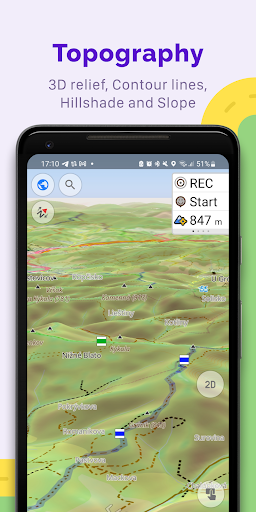
• Topo data (Contour lines and Terrain);
• Nautical depths;
• Offline Wikipedia;
• Offline Wikivoyage - Travel guides;
Map view
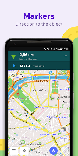
• Choice of places to be displayed on the map: attractions, food, health and more;
• Search for places by address, name, coordinates, or category;
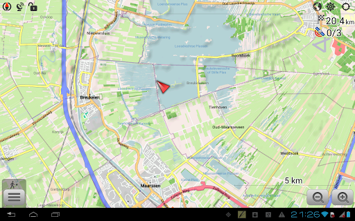
• Map styles for the convenience of different activities: touring view, nautical map, winter and ski, topographic, desert, off-road, and others;
• Shading relief and plug-in contour lines;
• Ability to overlay different sources of maps on top of each other;
GPS Navigation
• Plotting a route to a place without an Internet connection;
• Customizable navigation profiles for different vehicles: cars, motorcycles, bicycles, 4x4, pedestrians, boats, public transport, and more;
• Change the constructed route, taking into account the exclusion of certain roads or road surfaces;
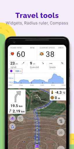
• Customizable information widgets about the route: distance, speed, remaining travel time, distance to turn, and more;
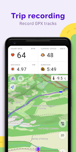
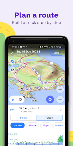
Route Planning and Recording
• Plotting a route point by point using one or multiple navigation profiles;
• Route recording using GPX tracks;
• Manage GPX tracks: displaying your own or imported GPX tracks on the map, navigating through them;
• Visual data about the route - descents/ascents, distances;
• Ability to share GPX track in OpenStreetMap;
Creation of points with different functionality
• Favourites;
• Markers;
• Audio/video notes;
OpenStreetMap
• Making edits to OSM;
• Updating maps with a frequency of up to one hour;
Additional features
• Compass and radius ruler;
• Mapillary interface;
• Nautical depths;
• Offline Wikipedia;
• Offline Wikivoyage - Travel guides;
• Night theme;
• Large community of users around the world, documentation, and support;
Paid features:
OsmAnd Pro (subscription)
• OsmAnd Cloud (backup and restore);
• Cross-platform;
• Hourly map updates;
• Weather plugin;
• Elevation widget;
• Customise route line;
• External sensors support (ANT+, Bluetooth);
• Online Elevation profile.
평균 평가
40.69K+
평가 내역
추천 리뷰
Sean “Seanzky” Ong 작성
2024-12-06
버전 4.9.7
The closest to a perfect navigation app for moto adventuring and moto camping. The only thing I would add is to make the menus more intuitive. Perhaps reorganize things menu items? For example, if the tracks/GPX was a little easier to manage, that would be awesome. I always forget where to find the folders containing the tracks. Also, moving tracks to one folder doesn't always work. Move should be cut, not copy. There are other things that I wish could be improved upon.
J Bondo 작성
2024-12-12
버전 4.9.9
Hate itSpendingZero search results by street address. I zoom in and see the street address listed for every single house in the entire area and I go to search the exact same address that shows on the zoomed in map and search has zero results. I've looked at all kinds of settings and I just can't figure it out. I've spent 2 hours on this now. Really frustrating for a product that cost this much
Jason B 작성
2024-04-17
버전 4.7.9
Hate itUpdatesRegarding the recent update, thank you! The update gave us the ability to add custom buttons to the screen and one option was switching between day and night mode. I use this app for navigation on a tablet mounted to my bike. During morning and evening, and when passing under overpasses, the app would switch between day and night, which was really annoying. Now I have the option to force it into one mode and to switch it as the morning brightens or the night darkens. Again, thank you.
스크린샷