Trailforks
Trailforks
3.2
Advertisement
릴리스 세부정보
| 발행국 | US |
| 국가 출시일 | 2015-08-04 |
| 카테고리 | Maps & Navigation, Sports |
| 국가 / 지역 | US |
| 개발자 웹사이트 | Trailforks |
| 지원 URL | Trailforks |
| 콘텐츠 등급 | Teen |
Advertisement
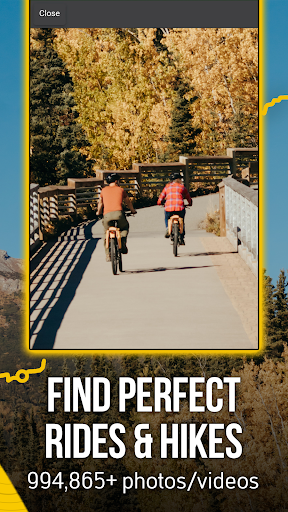
Plan the ultimate bike ride with Trailforks. Explore the best of bike apps with tools to help make the most of your mountain biking, moto dirtbiking, fatbiking, trail running, and more. Trailforks is the ultimate backcountry navigator made for all your off-road adventures. Get a bike tracker with detailed trail maps, bike GPS, condition reports, and route planning tools all in Trailforks.
Explore 670,000+ trails in your pocket, perfect for your next biking adventure, cycling training, and everything in between. Our bike ride tracker is filled with accurate, up-to-date stats and info for all of your rides. Download today and get started.
TRAILFORKS FEATURES
THE BEST OF CYCLING APPS
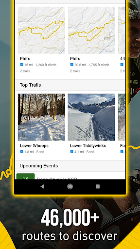
- Biking app with the world’s largest trail database
- Bike ride options for fat biking, cyclocross, dirt biking and more
- Bike GPS with GPX compatibility. Sync your Garmin or Wahoo device
- Take your next bike ride offline when you download our free cycling maps
- Our bike ride tracker lets you create your own local routes
- View bike route & region info with 1 million photos, videos, and 3M trail reports
- Free cycling app with quick links and directions to nearby bike shops
- Cycle through fatbike trails and backcountry routes
- Get a cycling tracker with route info & average time to complete
MULTI-ACTIVITY SUPPORT
- Fatbike, cycle, & more!
- Not just for bikers – find routes for hiking, trail running, skiing, and more.
- Free maps with thousands of related activity points of interest (POIs).
- Topo maps are yours to prepare for your next outdoor adventure
- Hiking Maps: Discover, plan and explore routes & trails
GPS NAVIGATION
- Bike GPS features for seamless navigation
- Bike ride tracker, run tracker & more – all in one
- Orientate road maps in the direction you’re facing
TOPOGRAPHIC MAPS AVAILABLE ONLINE & OFFLINE
- Offline topo maps and information with fast, incremental region updates
- Bike ride with route elevation profiles displayed in-app
- Explore free maps with a growing list of routes
- Toggle Pro map layers like slope angle, light pollution, USFS, land ownership, avalanche data & more!
- Get the best of bike apps with route creation to your preferred trailhead
- Up your outdoor game when viewing Strava segments
- Overlay of US land owners like the BLM
- View polygons for private property or closed areas
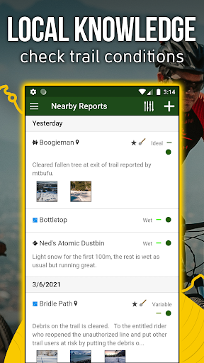
TRAIL EVENTS, STATUSES & ALERTS
- Save bike trails to your Wishlist
- View events nearby or by region
- Share your map location with friends & emergency services
- Your cycling tracker monitors trail conditions & closures
- Submit trail reports, including photos of trail issues
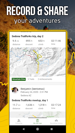
- Record each bike ride and earn local trail badges
- Sync and view saved ‘Route Plans’ from web to app
UPGRADE YOUR RIDE WITH TRAILFORKS PRO WITH OUTSIDE+
- Unlock nationwide map access, including Garmin base maps
- Priority sync with your Garmin or Strava device
- Enjoy unlimited waypoints & wishlists
- Access desktop-to-app cycling tools like printmap & downloadable GPX & KML files
- Unlimited access to the Gaia GPS offroad & hiking app
- Expert-led online courses on Outside Learn
- Premium access to award-winning films, shows, and live TV on Outside Watch
- Unlimited digital access to Outside Network’s 15 iconic brands including Outside Online, Velo, and Pinkbike
Trailforks is the perfect free cycling app for your outdoor adventures. Welcome the new season with the perfect bike tracker for your next ride – Trailforks!
Detailed trail maps for renowned mountain biking destinations such as, Whistler, Squamish, North Shore, Kamloops, Nelson, Moab, Sedona, Park City, Hurricane, Downieville, Colorado Springs, Bellingham, Bentonville, Finale Ligure, Pisgah, Marin, Bend Oregon, Wellington & Rotorua New Zealand.
평균 평가
16.06K+
평가 내역
추천 리뷰
A E 작성
2024-08-30
버전 2024.6.0
BugsSpendingIt used to be a great app before Outside got their hands on it. We lost features and functionality while the price jumped drastically all for corporate greed. It used to be by the riders / for the riders. The riders are responsible for all the trail maps, reports etc. I was ok paying $36 a year to support the app. But price increase for an app that doesn't always work now is a problem. Applause REI for keeping mtb project free and about the riders. Not as many features but it is now my go to.
Mike 작성
2024-08-20
버전 2024.5.1
BugsDeviceHate itPricingSpendingDon't waste your time. Free version was built by their users, but is now nearly useless, and any useful feature's locked behind subscription prices that increase with no worthy updates. Android app is highly buggy, aggravating to navigate, and surprisingly out of date in relation to the trails (probably due to chasing off their users that supplied all the trail data in the first place).
Gregory Andersen 작성
2024-08-10
버전 2024.4.2
Hate itPricingSpendingApp gets worse (including PRO) while prices go WAY up!! The free version is next to useless but the PRO subscription is way too expensive. You lost a PRO customer. I can easily live without it. (meaning it WAS a small luxury. Not even close to being a necessary app for most outdoor enthusiasts)..... 2nd, adding things like "national scenic trails" layer for example, that you can't permanently disable is an annoying distracting layer. Even dumber that you can't disable it in free version
스크린샷