Avenza Maps: Offline Mapping
Avenza Systems Inc.
3.8
Advertisement
Advertisement
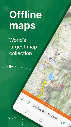
Avenza Maps, the best app for hiking, biking and all trails. Featuring maps from National Geographic, national parks and more! On your next adventure, stay on track with GPS using offline mobile maps. Make your own maps? Import your custom maps and never get lost off the grid.
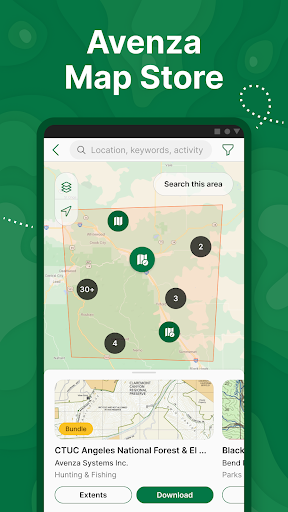
Explore the largest mobile Map Store of hiking, topographic, cycling, city, nautical, travel, and trail maps. Featuring maps from professional publishers including National Geographic, National Park Service, and the US Forest Service. Discover maps for your next camping, fishing, or backpacking trip with your family and friends. Navigate confidently when off-roading or taking those backcountry trails. Precisely identify your location with what3words and stay safe wherever you are.
Avenza Maps is free and the best map app for recreational use. Maps are available for free or purchase from the in-app Map Store. Plus subscription is available for unlimited custom map imports. Pro subscription is available for professional users with full access to all features and mapping tools.
Avenza Maps for your offline adventures on all trails!
ENHANCE YOUR MAPS WITH THESE FEATURES
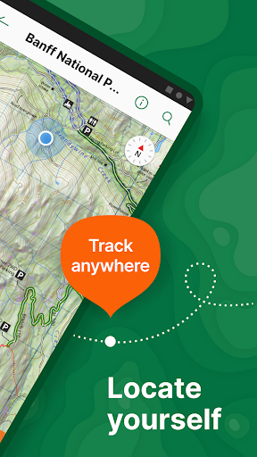
- Locate your realtime GPS position and find direction, even when offline
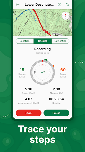
- Record GPS tracks during your activities
- Navigate to features using compass tools
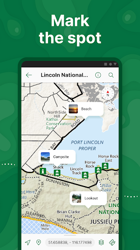
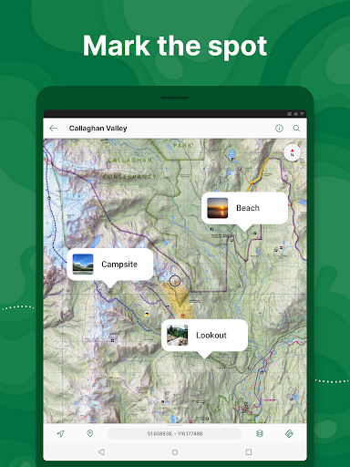
- Add photos and notes to any location
- Add placemarks to your map and style them with recreational symbols
- Measure distances and estimate times
- Supports KML, GPX, and CSV Formats
EXPLORE THE MAP STORE
Search and download maps by activity, category, and specific publishers with premium maps from:
- National Geographic
- Michelin
- Backroad Mapbooks (BRMB)
- New York-New Jersey Trail Conference
- USFS (United States Forest Service)
- USGS (United States Geological Survey)
- FAA (Federal Aviation Administration)
- NOAA (National Oceanic and Atmospheric Administration)
- BLM (Bureau of Land Management)
- HarperCollins
- DeLorme Atlas & Gazetteer / Garmin
- BaseImage
- National Park Service
- And thousands more!
A free account lets you access all of your map downloads.
GET MORE WITH AVENZA MAPS PLUS
For recreational and power users who need more
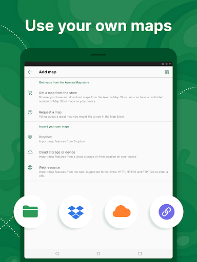
- Unlimited import of your own geospatial PDF, GeoPDF®, and GeoTIFF maps
- Create geofences for up to 50 individual features and up to four geofence layers
GET EVEN MORE WITH AVENZA MAPS PRO
For professionals and organizations who require an offline mapping solution with location awareness with more features and tools
- Unlimited import of your own geospatial PDF, GeoPDF®, and GeoTIFF maps
- GPS averaging, additional coordinate display formats, custom symbol sets
- Connect high-accuracy GPS devices including Trimble, Bad Elf, and Dual via Bluetooth
- Created unlimited geofences and get global geofence notifications
- Convert tracks to areas
- Map orientation lock
- Import and export Esri® Shapefiles
- Import and manage custom symbology sets
- Priority technical support
Avenza Maps Pro subscription required for commercial, academic, government, and professional use.
SUPPORT
We can help! Go to support.avenzamaps.com
LEGAL
Privacy Policy: avenzamaps.com/legal/privacy-policy.html
Terms of Use: avenzamaps.com/legal/terms.html
CONNECT WITH US
avenzamaps.com
facebook.com/avenzamaps
twitter.com/avenzamaps
instagram.com/avenzamaps
릴리스 세부정보
| 발행국 | US |
| 국가 출시일 | 2013-09-19 |
| 카테고리 | Maps & Navigation |
| 국가 / 지역 | US |
| 개발자 웹사이트 | Avenza Systems Inc. |
| 지원 URL | Avenza Systems Inc. |
| 콘텐츠 등급 | Everyone |
평균 평가
90.96K+
평가 내역
추천 리뷰
Joey Hughes 작성
2024-10-06
버전 5.3.3
NetworkOnly ever hiked the palmetto trail, specifically in the lower half of SC. The maps are provided by the palmetto trail conservancy but are on this app as an offline option. Maps (from PTC) are accurate. Only once have i had a campsite marker be off. the campsite was there it was just off in the distance from where it was located on the map. Nice app with plenty of functions. I use it all the time and trust it.
Spencer Feuchtwanger 작성
2024-08-28
버전 5.3.3
Feature RequestsHate itI use this app to preplan for atv backpacking trips. It's very helpful, but I could still use some improvements. When planning routes, it would be great if we could click from point to point on a road or trail existing on the map, and it would trace it automatically. Also, tracing routes manually on my phone kinda sucks. It would be 100x faster if I could do this on a computer instead and load my new layers onto my phone.
Allen Chien-Hwa Huang 작성
2024-08-16
버전 5.3.3
CameraFeature RequestsLocationLove itSpendingWaitingFairly user friendly. It didn't take too long for me to get into it. I would definitely recommend it to my friends if they want to do some GPS surveys and identify the data points on the map with photos and descriptions. You can also export the data compatible to Google Earth, Google Map for data sharing. And it's free. I don't need to pay. Thank you Avenza Maps. Cheers.
스크린샷