National Hurricane Center Data
LW Brands, LLC
4.8
Advertisement
Détails de la Version
| Pays de l'Éditeur | US |
| Date de Sortie dans le Pays | 2017-10-05 |
| Catégories | Weather |
| Pays / Régions | US |
| URL de Support | LW Brands, LLC |
| Évaluation du Contenu | 12+ |
Advertisement
Download the most comprehensive Hurricane Tracker app for iOS.
MAIN FEATURES INCLUDE:
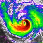
+ GOES Satellite Imagery Animations
+ National Hurricane Center Products
+ National Weather Service Alerts
+ Weather Prediction Center Graphics
+ Tropical Weather Push Notifications
+ Satellite Imagery Home Screen Widget
+ Spaghetti Models
GRAPHICAL PRODUCTS INCLUDE:
Forecast Graphics
- Spaghetti Models
- 7-Day Tropical Weather Outlook
- 3-Day Excessive Rainfall Outlook
- 7-Day Quantitative Precipitation Forecast
Storm Specific Graphics
- Key Messages
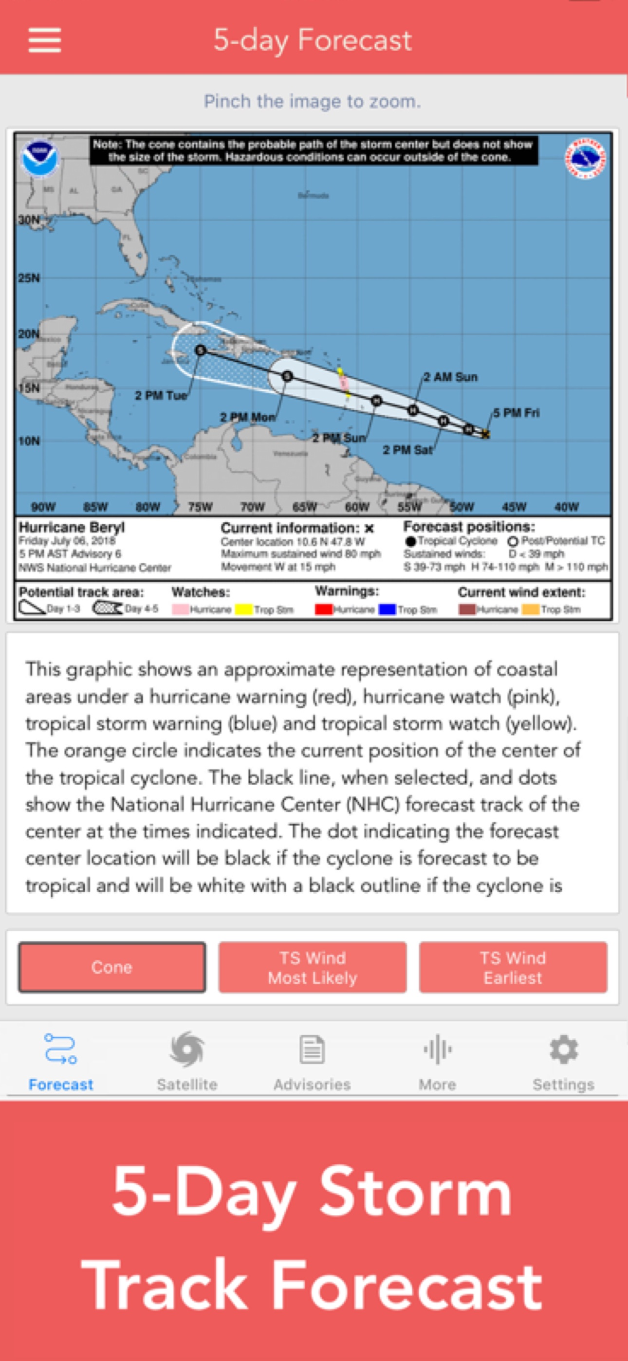
- Cone Track Forecast
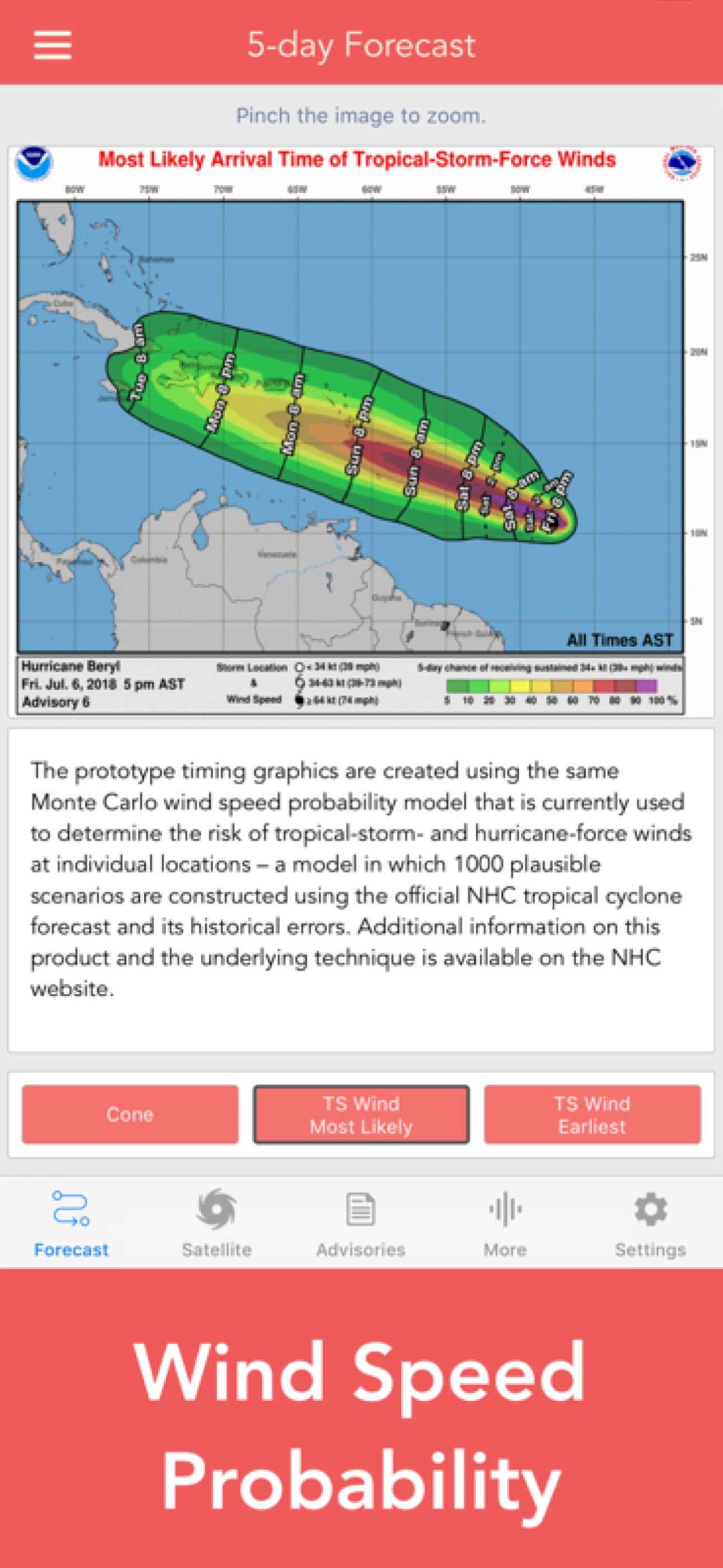
- Tropical Storm Wind (Most Likely)
- Tropical Storm Wind (Earliest)
- Hurricane Wind Probability
- Surface Wind Field
- Surface Wind Analysis
- Wind / Track History
- Rainfall Forecast
- Flash Flood Risk
Local Storm Threat Graphics
- Flooding Rain Threat
- Wind Threat
- Surge Threat
- Tornado Threat
- Rainfall Totals
- Wind Warnings
Note: Local threat graphics are typically not available until shortly before storm landfall.
TEXT PRODUCTS INCLUDE:
- Tropical Weather Outlook
- Forecast Advisories
- Public Advisories
- Forecast Office Discussion
- Local Statement (HLS)
- Local Warnings (TCV)
- Tropical Discussion
- Wind Analysis
WEATHER MAP OVERLAYS INCLUDE:
- Hurricane Track & Intensity
- Potential Storm Surge Flooding
- NASA Sea Surface Temperature
- NOAA Weather Radar
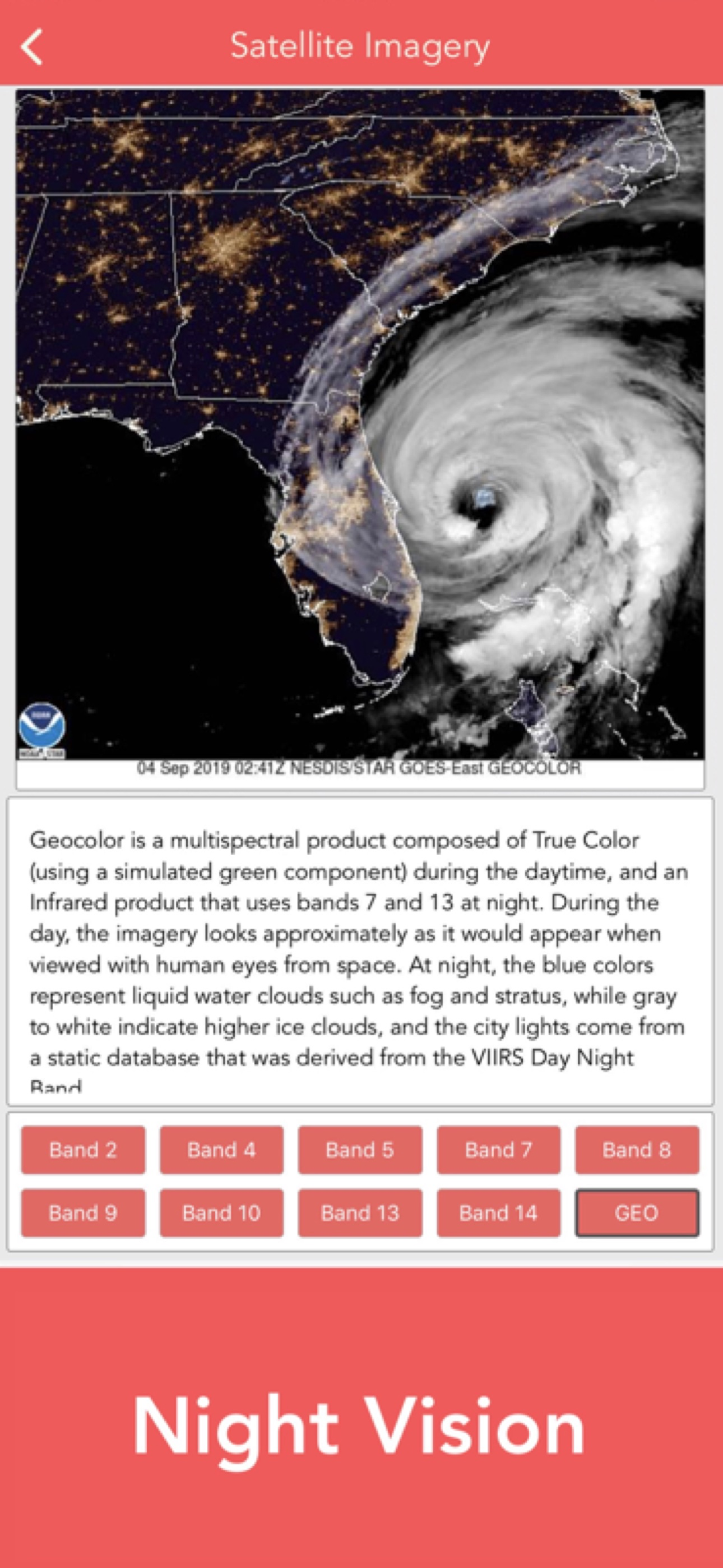
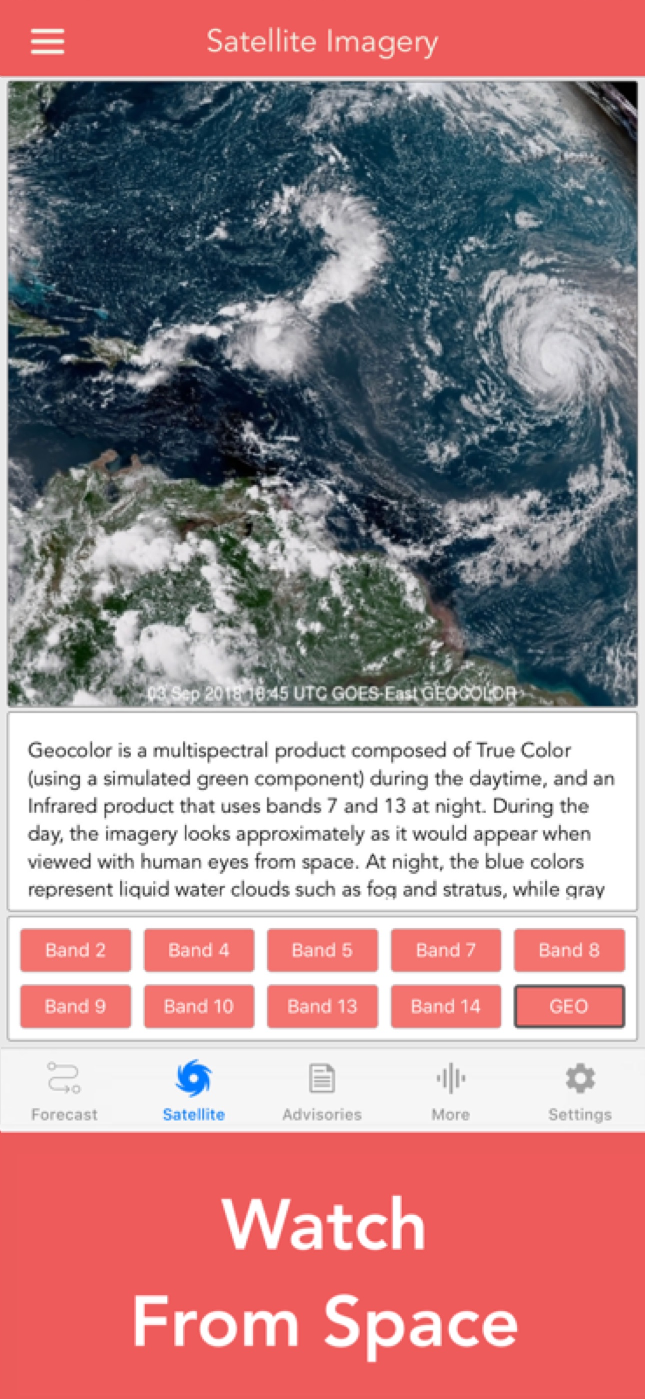
GOES SATELLITE IMAGERY INCLUDES:
Fifteen (15) Satellite Imagery Filters
- Visible (Band 2)
- Near IR (Bands 4 & 5)
- Infrared (Bands 7, 8, 9, 10, 13, 14 & 16)
- Nighttime Microphysics
- Day Cloud Phase
- True Color
- Air Mass
- Sandwich
APPLE WATCH APP INCLUDES:
- View wind speed & intensity updates every 30 minutes
- View the latest satellite imagery
- Choose from a variety of Watch Complications
– PRO SUBSCRIPTION FEATURES –
Full Screen, High Resolution Satellite Imagery:
- Latest Image
- Animated Loop
- Mesoscale: Near Real-time Imagery
- Geostationary Lightning Mapper (GLM)
Mesoscale imagery typically has 1-minute temporal resolution, but is not always available for each storm.
16-day Weather Forecast Models:
- Global Forecast System (GFS)
- Global Ensemble Forecast System (GEFS)
- North American Ensemble (NAEFS)
Weather Simulation Forecast Models:
- Hi-Res Rapid Refresh (HRRR)
- Hi-Res Ensemble Forecast (HREF)
- North American Mesoscale (NAM)
- Hi-Res North American Mesoscale
(NAM-HIRES)
- High Resolution Window
(HRW-FV3, HRW-ARW, HRW-ARW2)
- WaveWatch III (WW3)
- European Centre for Medium-Range Weather
(ECMWF)
HMON & HWRF Hurricane Forecast Models
Experimental Forecast Animations:
- Simulated Radar 2km
- Surface Pressure, Wind
- 200mb Temp, Ht, Wind
- 700mb RH, Ht, Wind
- 850mb Vort, Wind, Thick
Model Analysis & Guidance Animations:
- 6h Total Precipitation
- 10m Wind
- 200mb Vort, Wind, Ht
- 500mb Relative Humidity
- 700mb Vort, Wind, Ht
- 850mb Vort, Wind, Ht
Static Forecast Products
- Track*
- Intensity*
- Pressure*
- Rain
- Wind
* Track, Intensity and Pressure graphics include spaghetti plots when available. Models included in spaghetti graphics include: HWRF, HMON, CTCX, AVNO, SHF5 & OFCL.
NCEP / EMC Cyclogenesis Tracking Products
- 16-day Storm Forecast Tracks
- 21-day Global Tropics Hazards Outlook
- 35-day Probability of Formation
CIMSS Tropical Cyclone Products
- Wind Vorticity & Shear Analysis
- Steering Layer Analysis
- Morphed Integrated Microwave Imagery
- Advanced Dvorak Technique (ADTV9.0)
ADT Includes imagery, wind radii estimates & trends
Interactive Hurricane Tracker Map
- Track & Intensity Forecast
- Preliminary Best Track Analysis
TERMS & CONDITIONS
https://lwbrandsllc.com/hurricane-app-terms-conditions/
–
In total, there are now over 100+ hurricane / weather tracking products to help you stay informed during hurricane season.
Évaluation Moyenne
60.61K+
Répartition des Évaluations
Avis Sélectionnés
Par SueinNC
2024-08-05
Version 1.48
Feature RequestsLevelLove itThis is the second Storm I am using the app. I like having all the info I need in one place. Most of us boaters use 3 or more weather forecasting apps and this one is a bit different. Having the spaghetti models of this one plus the models of my other apps all tie together the questions I will have to answer in the next 24 hours. I think the app will help with this. How far above flood stage might the Nuse River rise. If I have my boat hauled out is it high enough that my boat wont float off the blocking- Do we need to make a run from New Bern NC to Portsmouth Va as our marina cant take 60 mph gusts. It seems that some people do not realize app uses NOAA products but is an excellent non governmental app.
Par Mr. Guinness
2024-08-02
Version 1.48
CameraFeature RequestsLevelSpendingNot bad, but mapping is too tiny for any intelligent reader,( particularly the smaller screen size on a phone, for example) to buy, particularly the size and direct intensity levels to be “possible”, not actually expected. It creates a slight “panic” edge for readers. Topography has major impacts, as well as intensity, more education on those factors reduces the “oh God, we’re all gonna be killed, or just crushed!” Perhaps more pre placement, or directly educative programming can do millions of dollars of simple pre-education before they wake up and say “now I understand, and can “rate” and understand what they are talking about!” You NEED to developed your “on camera, or “on air folks to reason and % of probability tools to a) provide information , and b) earn the RESPECT of viewers by verifiable data, and WHAT IT REALLY MEANS, simply with Reasonable back up data, and pix’s!
Par Hammerklan
2024-07-06
Version 1.45
Feature RequestsUpdatesHurricane Tracker is my Go-To app for Tropical Updates from June thru November to stay abreast and in-the-know. I’m a Gulf Coast resident and hurricanes are just another part of life like grocery shopping and retirement planning. There’s lots of places to get my groceries and lots of places to invest my future, but quality and performance rule the day. That’s why I trust Hurricane Tracker to be my eyes and ears for hurricane awareness - Quality & Performance. I can quickly get the info I need to make fast, situational-awareness planning decisions from a logical format. If the situation warrants and I need to dig deeper, the latest information is all in the app for keeping me abreast of the current state and the predicted projections. Quality & Performance.
Captures d'Écran