ForeFlight Mobile EFB
ForeFlight
4.7
Advertisement
Detalles de la Versión
| País del Editor | MX |
| Fecha de Lanzamiento en el País | 2009-12-16 |
| Categorías | Navigation, Weather |
| Países / Regiones | MX |
| Sitio Web del Desarrollador | ForeFlight |
| URL de Soporte | ForeFlight |
| Clasificación de Contenido | 4+ |
Advertisement
Download for a 30-day free trial of our top subscription plan! Visit our website for more information on available plans and add-ons.
ForeFlight is the leading flight app for VFR and IFR pilots everywhere, making flight planning and flying easier, safer, and more enjoyable.
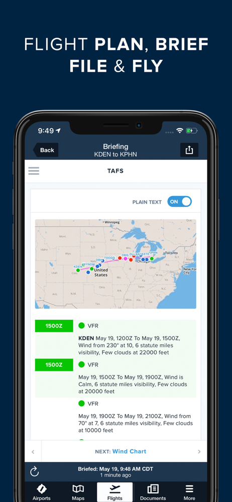
FLIGHT PLANNING, BRIEFING, & FILING
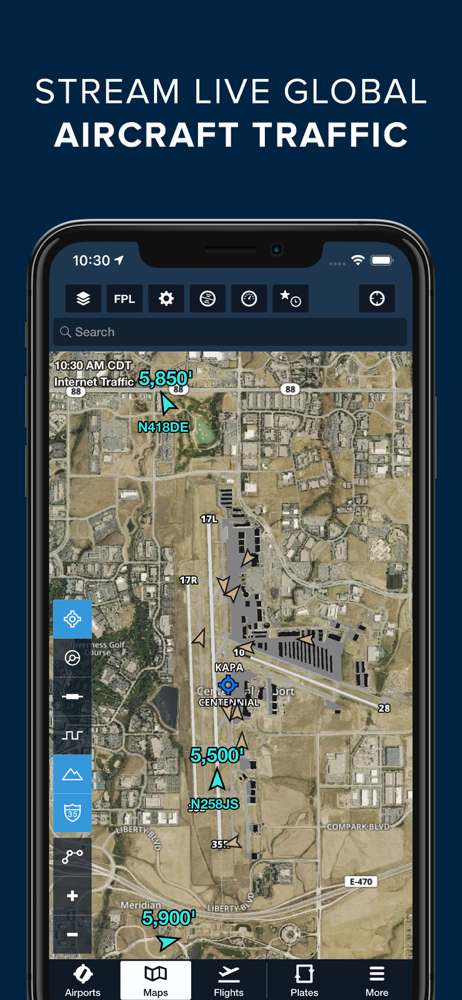
Plan flights with Touch Planning on the Map or full-featured form-based Flights view. Tap out a route in seconds and quickly see if flights will be affected by weather or TFRs. Helpful Route, Altitude, and Procedure Advisors make planning easy and accurate. Generate a graphical preflight briefing and file your flight plan directly from the app. Print a professional-grade Navlog for inflight reference.
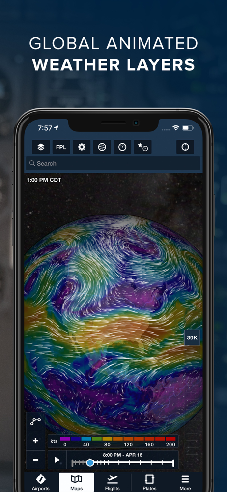
WEATHER
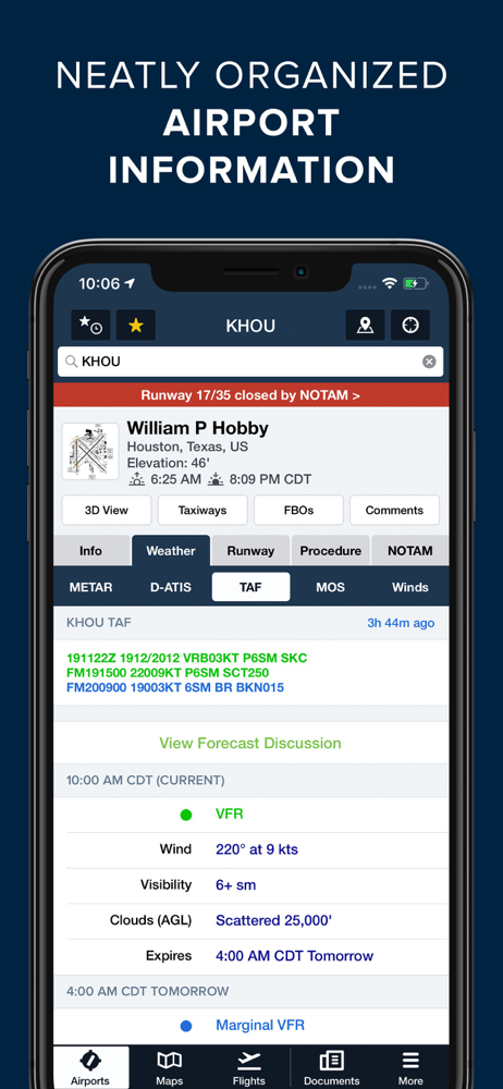
Interactive weather layers include animated radar, global satellite and winds aloft, global icing, turbulence, and surface analysis, graphical AIR/SIGMETs, flight category, visibility, and more. View decoded METARs, TAFs, and MOS forecasts. Thoughtfully organized Imagery view puts a full range of forecast tools at your fingertips.
PLATES, CHARTS, & MAPS
Both VFR and IFR operations are covered with all of the essentials required for planning and navigation: data-driven Aeronautical Maps, VFR Sectionals, High/Low Enroute charts, SIDs, STARs, approach and taxi charts, and terrain, satellite, and street map views.
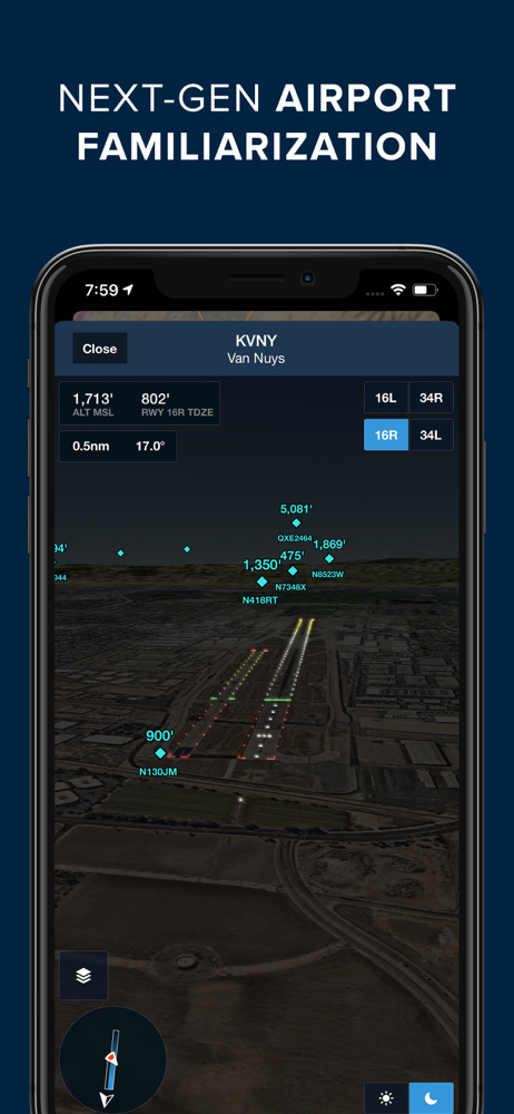
GEO-REFERENCED APPROACHES & TAXI CHARTS
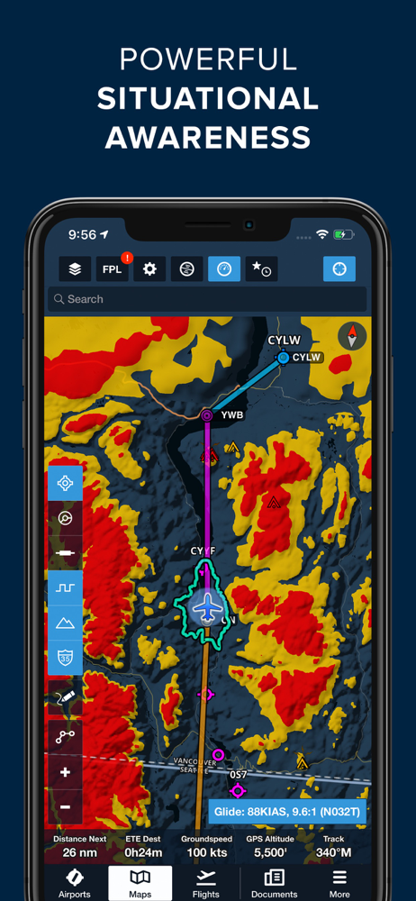
Plates and taxi charts enable the real time display of your GPS location on the chart. They can also be overlaid on the Maps view along with weather and hazards for the ultimate situational awareness.
GLOBAL HAZARD AWARENESS TECHNOLOGY
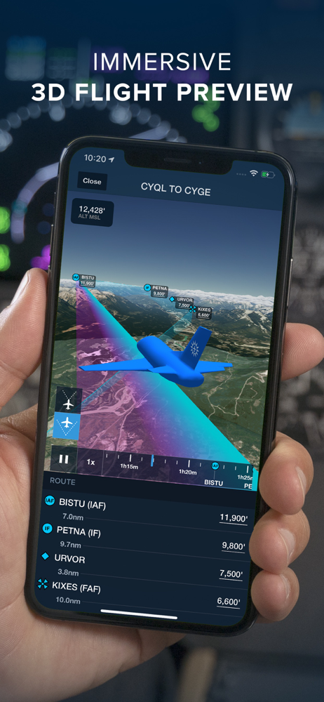
Plan and fly with more confidence in all conditions and terrain. Top-down-view Hazard Advisor map layer, Terrain Profile View, and 3D Synthetic Vision seamlessly integrate into the map display to depict a clear picture of terrain and obstacle hazards anywhere in the world. When paired with an AHRS source, Synthetic Vision provides a backup attitude display.
LOGBOOK
Logbook makes it easy to log and share flights, track hours, review currency, record certificates and ratings, receive electronic instructor endorsements, and create experience reports. Your data is automatically synced across all your devices and protected in secure cloud storage.
ADDITIONAL FEATURES INCLUDE:
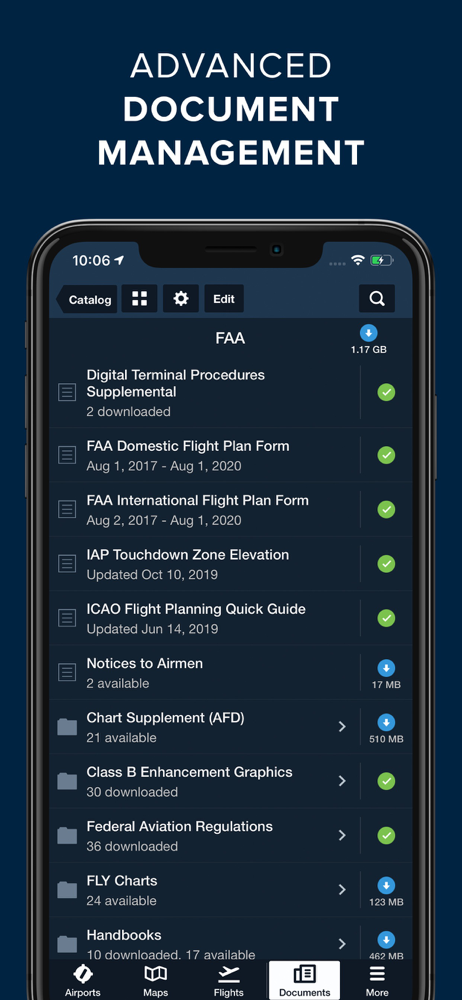
Built-in documents catalog with FAR/AIM, charts supplements, and more
Airport, FBO, and fuel price information for thousands of locations
Dynamic data-driven Aeronautical Maps
Weight & Balance
Glide Advisor
Automatic chart and data data updates
Chart color inversion for better night flying experience
Access to web planner
Download ForeFlight Mobile EFB
Not Available
Calificación Promedio
39
Desglose de Calificaciones
Reseñas Destacadas
Por Reloj despertador
2019-10-26
Versión 11.9
Excelente App y muchísima información. Lo único es que deberían de incluir Cartas zona de cobertura en Mexico ya que la mayoría conocen esta app y muchos la utilizan.
Por CapOliden
2024-05-01
Versión
Es una herramienta muy útil para la navegación, toda la información que presenta y las constantes actualizaciones ayudan mucho en todos los vuelos
Por Rafa hawker 850 xp
2020-12-18
Versión 12.11
Muy buen apoyo en mi idioma del Sr Albert para uso de la app en mi ihpad
Capturas de Pantalla