PeakFinder
Fabio Soldati
4.4
Advertisement
Release Details
| Publisher Country | US |
| Country Release Date | 2011-03-17 |
| Categories | Travel & Local |
| Country / Regions | US |
| Developer Website | Fabio Soldati |
| Support URL | Fabio Soldati |
| Content Rating | Everyone |
Advertisement
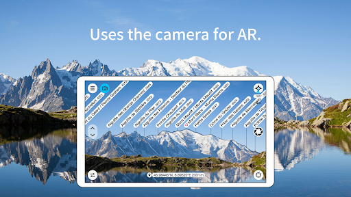
The mountains are calling! Explore more mountains than any mountaineer! PeakFinder makes it possible… and shows the names of all mountains and peaks with a 360° panorama display.
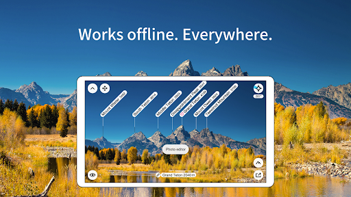
This functions completely offline - and worldwide!
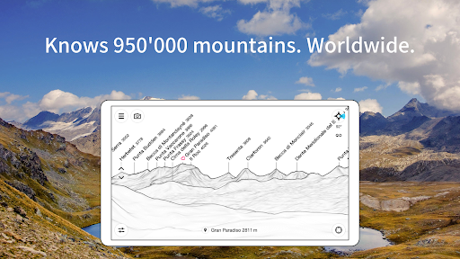
PeakFinder knows more than 1’000’000 peaks - from Mount Everest to the little hill around the corner.
•••••••••
Winner of several prizes. Highly recommended by nationalgeographic.com, androidpit.com, smokinapps.com, outdoor-magazin.com, themetaq.com, digital-geography.com, …
•••••••••
••• Features •••
• Works offline and worldwide
• Includes more than 1’000’000 peak names
• Overlays the camera image with the panorama drawing *
• Realtime rendering of the surrounding landscapes in a range of 300km/200mil
• Digital telescope to select less prominent peaks
• ‘Show me’-function for visible peaks
• Selection of the viewpoint by GPS, the peak directory or an (online) map
• Mark mountains and places you like
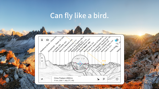
• Can fly like a bird from peak to peak and vertically upwards
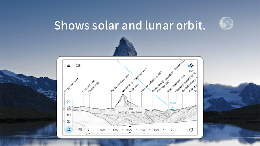
• Shows the solar and lunar orbit with rise and set times
• Uses compass and motion sensors
• Daily updates of the peak directory
• Does not contain any recurring costs. You pay only once
• Is free of advertising
* On devices without a gyroscope and a compass sensor the camera mode is not supported.
Average Rating
13.84K+
Rating Breakdown
Featured Reviews
By Eric Miller
2024-12-29
Version 4.8.30
DifficultFeature RequestsBetter than most with room for improvement. Its hard to read outdoors because it's black and white with whisper thin lines and tiny text (would be nice if text could magnify). The field is view doesn't precisely line up with what the eye sees. You have to try to first find a peak you can match up then go from there. My biggest criticism is that the silhouettes of the peaks are a bit lacking in detail so for example clearly jagged peaks look quite rounded in the app making them harder to ID.
By Mike Berger
2024-09-11
Version 4.8.25
Hate itLocationGreat concept, though execution leaves much to be desired. Doesn't orient correctly, so you have to know what peaks you're looking at in order to figure out what peaks you're looking at -- which defeats the entire purpose of the app. This is a major flaw and therefore not worth the price of admission. Wish I could get a refund. Running on Google Pixel 7 Pro and this is the only app using GPS that can't orient itself correctly.
By Tomaash Cernik
2024-09-14
Version 4.8.25
CameraFeature RequestsGreat app. Here's a feature idea. I mostly use this on my photos in post process, where there is often not enough room above the peaks for your labels. It would be ready handy if PeakFinder had the option to change the canvas size of the photo to make enough room for the labels above the peaks. And you could add styles of the transformation into a color of choice (black line, gradient, ai generated sky etc.). It would be especially useful since even apps like PS can't change canvas size. Thanks
Screenshots