Footpath Route Planner
Half Mile Labs LLC
4.8
Advertisement
Release Details
| Publisher Country | US |
| Country Release Date | 2020-09-29 |
| Categories | Maps & Navigation |
| Country / Regions | US |
| Developer Website | Half Mile Labs LLC |
| Support URL | Half Mile Labs LLC |
| Content Rating | Everyone |
Advertisement
Trace a map with your finger and Footpath will snap to roads and trails. Measure distance and elevation in seconds, then follow along with turn-by-turn voice navigation.
Mix up your routine and plan out a new running route or bike ride, or plan a scenic road trip or multi-day hiking adventure. Footpath allows you to plan custom routes quicker and easier than ever before.
Join millions of adventurers using Footpath Route Planner and pave your own path.
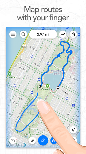
Snap to map
Quickly measure distances by tracing a map with your finger. Footpath will snap to any roads, bike paths, hiking trails, or paths you can find on Footpath’s topo maps. Footpath can even snap to rivers and railroads.
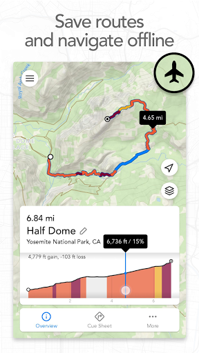
Measure distance and elevation
Know exactly how far and how high you’ll travel with an accurate distance measure and detailed elevation profiles. Plan a precise route that matches your mileage goal, or use as a GPS distance tracker if you run without a plan.
Save routes for later
Marathon training or planning a backpacking trip? Sign up for a free account to save up to 5 routes at a time, or save an unlimited number of routes with Footpath Elite.
GPX viewer
Find a cool hiking trail on the web? Import GPX files from anywhere to analyze or save for later.
Share routes
Send your routes to friends or workout partners and let them partake in your adventure.
Footpath is designed to work in any country, and for any activity or adventure you can imagine:
• Running, walking, and hiking
• Cycling and mountain biking
• Motorcycling and driving
• Kayaking, canoeing, and standup paddleboarding
• Backcountry skiing
• Sailing
• And many more!
———
Footpath Elite
Ready to go the extra mile? Upgrading to a Footpath Elite subscription unlocks the following powerful features:
• Turn-by-turn navigation: Footpath will tell you when to turn with turn-by-turn audio cues
• Premium topo maps & overlays: including USGS Topo Maps, OpenCycleMap, bike paths, avalanche slope shading, elevation contour lines, and many more
• Offline map downloads: follow your route even without cell service
• Organize: save unlimited routes and sort routes into custom lists
• Export: export GPX files directly to Garmin Connect, Wahoo ELEMNT, COROS, and other apps
• GPS Devices: export TCX and FIT courses for turn-by-turn navigation on select Garmin and Wahoo running watches and cycling computers
———
Tips for mapping routes
• For a longer route, try zooming in and mapping your route in multiple segments.
• Tap and hold the map to quickly route between waypoints and POIs.
• Did Footpath snap to the wrong roads? Trace over the incorrect segment to edit, or use the eraser tool.
• Turn off snap to roads (magnet icon) and zoom in to manually trace the map. (Try switching to a satellite layer).
———
Contact Us
We’ve got a lot planned for Footpath. If you have any suggestions or feedback, or if you run into any issues, please contact us at [email protected].
Average Rating
6.05K+
Rating Breakdown
Featured Reviews
By Amanda Bryan
2024-08-25
Version 2.2.9
My first introduction to Footpath was using it to create 2 weeks worth of walking tours around London. It worked so well! I adopted it when I decided to start running. I enter the route before each race and in the last fun run I did, I was the only one from my group that didn't get lost. I'm still learning new ways to use it and am currently playing around with importing and exporting routes. Great app. Thank you!
By DavidPrice PSU
2024-05-21
Version 2.2.8
NetworkSimple, easy to use, does precisely what I hoped it would do. I've gotten a couple of timeout hiccups, but when I zoom in and/or make shorter entries, I have no problem at all. I particularly like that there are in-town trails on this, too, so I can venture off of my streets into a known local path. Altogether a superior product for my uses, which primarily is relatively accurately estimating the length of a walk or run in areas known to me.
By PG
2023-11-12
Version
BugsNotificationsNot working, at all, after Nov 10th upgrade. Galaxy s23 Ultra. Previously had a horrendous bug. Trying to map route, if you came close to starting point, map would zoom out to full town zoom, forcing tedious zoom back to individual-streets zoom. I alerted Dev, months ago; no response. One of 2 apps to which I subscribed. Never again. Extra star bc it *was* great for years.
Screenshots