Zoom Earth - Live Weather Map
Neave Interactive
4.9
Advertisement
Advertisement
TRACK THE WEATHER IN REAL-TIME
Zoom Earth is an interactive weather map of the world and a real-time hurricane tracker.
Explore the current weather and see forecasts for your location through interactive weather maps of rain, wind, temperature, pressure, and more.
With Zoom Earth, you can track the development of hurricanes, storms, and severe weather, monitor wildfires and smoke, and stay aware of the latest conditions by viewing satellite imagery and rain radar updated in near real‑time.
SATELLITE IMAGERY
Zoom Earth shows weather maps with near real-time satellite imagery. Images are updated every 10 minutes, with a delay between 20 and 40 minutes.
Live satellite images are updated every 10 minutes from NOAA GOES and JMA Himawari geostationary satellites. EUMETSAT Meteosat images are updated every 15 minutes.
HD satellite images are updated twice a day from NASA polar-orbiting satellites Aqua and Terra.
RAIN RADAR & NOWCAST
Stay ahead of the storm with our weather radar map, which shows rain and snow detected by ground-based Doppler radar in real-time, and provides an instant short-term weather forecast with radar nowcasting.
WEATHER FORECAST MAPS
Explore beautiful, interactive visualizations of the weather with our stunning global forecast maps. Our maps are continually updated with the latest weather forecast model data from DWD ICON and NOAA/NCEP/NWS GFS. Weather forecast maps include:
Precipitation Forecast - Rain, snow, and cloud cover, all in one map.
Wind Speed Forecast - Average speed and direction of surface winds.
Wind Gusts Forecast - Maximum speed of sudden bursts of wind.
Temperature Forecast - Air temperatures at 2 meters (6 feet) above the ground.
“Feels Like” Temperature Forecast - Perceived temperatures, also known as apparent temperature or heat index.
Relative Humidity Forecast - How air moisture compares to temperature.
Dew Point Forecast - How dry or humid the air feels, and the point at which condensation occurs.
Atmospheric Pressure Forecast - The average atmospheric pressure at sea level. Low-pressure areas often bring cloudy and windy weather. High-pressure areas are associated with clear skies and lighter winds.
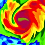
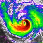
HURRICANE TRACKING
Follow hurricanes from development to category 5 in real-time with our best-in-class tropical tracking system. Information is clear and easy to understand. Our hurricane tracking weather maps are updated using the very latest data from NHC, JTWC, NRL, and IBTrACS.
WILDFIRE TRACKING
Monitor wildfires with our active fires and heat spots overlay, which shows points of very high temperature detected by satellite. Detections are updated daily with data from NASA FIRMS. Use in conjunction with our GeoColor satellite imagery to see the movement of wildfire smoke and monitor fire weather in near real-time.
CUSTOMIZATION
Adjust temperature units, wind units, time zone, animation styles, and many more features with our comprehensive settings.
ZOOM EARTH PRO
More features are available through auto-renewable subscriptions. Payment will be charged to your App Store account at the confirmation of purchase. The subscription will automatically renew at the end of each billing period and be charged within 24 hours, unless auto-renew is turned off at least 24 hours before the end of the current period. For further information, please read our Terms of Service.
LEGAL
Terms of Service: https://zoom.earth/legal/terms/
Privacy Policy: https://zoom.earth/legal/privacy/
Release Details
| Publisher Country | US |
| Country Release Date | 2023-06-27 |
| Categories | Utilities, Weather |
| Country / Regions | US |
| Developer Website | Neave Interactive |
| Support URL | Neave Interactive |
| Content Rating | 4+ |
Average Rating
27.22K+
Rating Breakdown
Featured Reviews
By Wyoming Man
2024-06-05
Version 2.2.1
InappropriateLove itThis app helps people who live outside to anticipate their weather. Various views help to anticipate winds, precipitation, temperatures, or cloud cover, as well as providing a bird’s eye view of surroundings (like fires, smoke, etc). Nearly instantaneous perspectives can make a huge difference for people who are exposed to the elements. If you desire to understand the science behind weather and forecasting, visit NCAR just SW of Boulder, CO. All the weather channels get their data from the USA government data, then repackage it. The supercomputers have made incredible progress during the last half-century. Zoom Earth has brought out quite a few features that still seem like science fiction, but they are amazingly accurate on the ground (especially when viewed on a tablet).
By Kristi1964
2024-04-01
Version 2.1
UpdatesYou can see current weather and see predicted weather up to a few days. You can see rain, wind speed and where clouds are expected to go. You can pinpoint a specific area on the map to see the weather as it effects that pinpoint. I’d like to be able to set more than one pinpoint at a time if possible. That would make it even better. You can see current fires and temperatures. I use this app all the time for weather updates on moving storms for myself and people I know in other areas. The weather is shown above the land mass with lines to separate the states. But you can also look at the entire planet. I use it almost every day.
By Allen Lieberman
2024-02-21
Version 2.0
DeviceLove itUpdatesThis app has come a long way since I found it. This latest update just put the app to one of the most detailed weather apps with the simplicity of never going beyond the main page. No submenus, no complicated paths to get lost in. All menu options are placed eloquently along the edges of the screen (ipad for me), not obtrusive or in your way of viewing the product whether it be satellite, radar, temperature history to any other important product that the weather services provide planet wide. While some other apps may provide highly detailed data, I have not come across another app with the simplicity of navigation like this app provides.
Screenshots