BaseMap: Hunting Maps and GPS
BaseMap Inc
4.2
Advertisement
Versionsdetails
| Herausgeberland | US |
| Veröffentlichungsdatum im Land | 2016-10-10 |
| Kategorien | Sports |
| Länder / Regionen | US |
| Entwickler-Website | BaseMap Inc |
| Support-URL | BaseMap Inc |
| Inhaltsbewertung | Everyone |
Advertisement
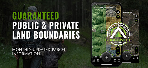
Guaranteed land ownership maps, mobile hunt planner with draw odds, industry leading GPS tools for hunters and outdoorsmen.
OFFLINE GPS and TRACKING
• Cache maps for offline use without service
• Save as many offline maps as you want with unlimited caching (Pro)
• Know exactly where you are in real time even without cellular coverage
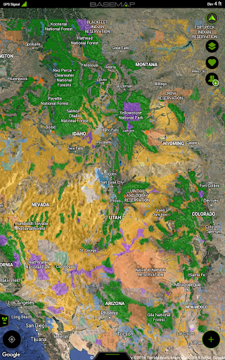
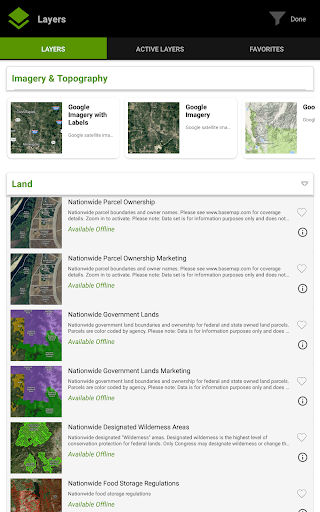
MAP LAYERS
• Over 800 layers and growing
• Nationwide Color Coded Govt Lands
• Nationwide Private Parcel Boundaries & Owner Names
• Water depths for East coast, West, Coast, Gulf coast, & over 4,000 U.S. lakes
• Nationwide Hiking Trails
• Nationwide Wildfires & Timber cuts
• Nationwide Wilderness & Roadless Areas
• State specific hunting layers including hunting unit boundaries, private hunting opportunities, WMA’s & more
• Multiple Topography & Satellite Imagery basemap options
• Much more
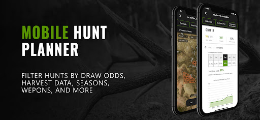
MOBILE HUNT PLANNER
• Unit filtering
• Draw odds
• Harvest data
• Season dates
• Unit insights
LRF MAPPING (Laser Rangefinder Mapping)
• Use your rangefinder as a powerful mapping tool
• Precisely mark the exact location of distant targets with ANY rangefinder
• Recover game, build routes, plan stalks, lookup distant property owners and more, all using your rangefinder!
MOBILE GPS
• Know your exact location even without cellular or WiFi service
• See where you are in relation to property boundaries, roads, trails, peaks, or boundaries
• Navigate to trail heads, favorite places, markers, or anything you need to locate with our powerful Search and GoTo features.
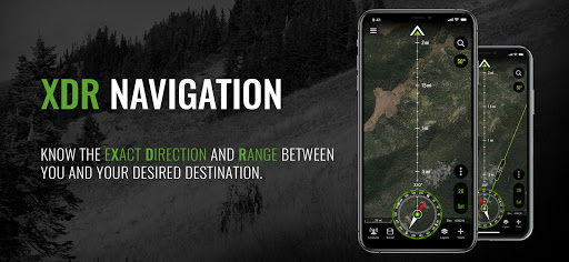
XDR (Exact Direction & Range) NAVIGATION TOOL
• Easy Point and Go navigation
• Know the exact distance between you and your destination.
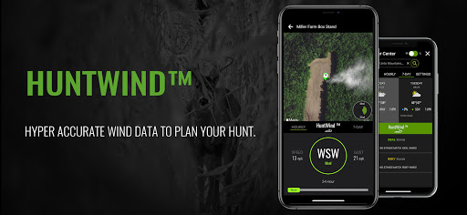
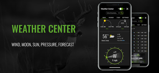
HUNTWIND™ & WEATHER CENTER
• Wind forecast to better plan your hunt.
• Know the exact day and time to hunt a particular stand and visualize wind direction and scent drift in relation to your location.
• Forecasts, temperature, moon phase, sunrise/sunset, wind, and more.
LOCATION SHARING
• Know exactly where your hunting partner is located
• Real-time updates
OUTDOOR JOURNAL
• Capture, log, and share all your outdoor adventures with the BaseMap community
• Real-time location sharing so friends can see where you are in case of emergency (connection reqd.)
• SmartMarkers - Automatically capture the weather conditions at the time you add a marker.
HARVEST LOG
• Log your hunts as detailed as you’d like. Record your hunt type, species/size, weapon, unit/GMU & much more.
•
GOOGLE EARTH INTEGRATION
• Export markers and view them right in Google Earth
• View the terrain in true 3D
DESKTOP APPLICATION
• Automatically sync all your data between your phone and the BaseMap web application.
SUBSCRIPTIONS
BASIC (Free)
• No Ads
• Connect with friends
• Hybrid 3D Imagery (map tilt).
• XDR Navigation
• Nationwide Roads, Trails & Points of Interest
• Nationwide Lakes, Rivers & Streams
• Hunting Unit boundaries
• GPS Location & Tracking
• Hi-Res Satellite Imagery
PRO ($39.99/yr)
• Everything in Basic plan
• Access to over 800 Layers
• Unlimited Data & Offline Use
• Nationwide parcel boundaries and owner names
• Nationwide color-coded government lands
• Google Earth Integration
• Import/Export KML and GPX with BaseMap web application
• Real-Time location sharing
• LRF Mapping (Laser Rangefinder Mapping)
PRO ADVANTAGE ($69.99/yr)
• Includes:
• BaseMap Pro subscription
• Global Rescue subscription for field advisory and rescue services
PRO ULTIMATE ($99.99/yr)
Includes:
• BaseMap Pro subscription
• Global Rescue subscription for field advisory and rescue services
• Mobile Hunt Planner tools: Unit filtering, draw odds, harvest data, season dates, and more
For questions or more information, contact us at: [email protected]
Privacy policy: https://www.basemap.com/privacy-policy/
Terms of use: https://www.basemap.com/terms-of-use/
Government Information: BaseMap Inc does not represent any government entity. You may find various links to public information within our data.
Sources: https://data.fs.usda.gov/geodata/
Durchschnittsbewertung
4.35K+
Bewertungshäufigkeit
Ausgewählte Bewertungen
Von Kyle D.
2024-11-07
Version 6.0.5
BugsLocationNetworkUpdatesWorks great better and better each year.........update And then it doesn't work when you need it. I was out elk hunting, this app just failed me. Won't upload any of my saved offline maps, crashes, and closed the app every time i tried dropping a location marker. It's not the first time i had issues, I'm done. Lost my business. After 5 years, I'm moving on.
Von A Google user
2024-10-12
Version 6.0.3
BugsHate itNetworkA lot of bugs, (offline maps downloads get stuck, sometimes forever, or slow down drastically at 66%, unit and elk zone names in Idaho are written on top of each other, layers load from your own phone painfully slow when offline, etc) and even their "report a bug" menu item does nothing. Shame, as the app would be great with all of the bugs resolved!
Von Wayne
2024-03-09
Version 5.2.12
CameraIf you are looking for a really good hunting app, this is it ! I have the other popular hunting apps on my phone, but Basemap is the only one I use now. This app stays up to date better than the others. I pulled up the satellite on all 4 of the apps and basemap was the only one that had the current aerial photos of my farm and the other 3 apps were all at least 3 months behind on the aerial/satellite photos of my farm. I know this as fact because of where my vehicles and tractors were parked.
Screenshots